Basin considered for Incorporation -Wittenberg
Teen Twins in SouthShore
Snyderville City? Summit County seriously considering the idea. – [Proposed new name “Moose Valley”] By Andrew Wittenberg on February 11, 2013
—Read his article at: http://www.ksl.com/?nid=148&sid=24044470
–Response:
We have lived in the Silver Springs Community for over 30 years. When we moved here we did not want to live in what we considered the Park City tourist area. We have always disliked the name “Snyderville” though we have Snyder ancestors from the 1846 era who were among the first settlers in this Summit County, Utah area. The unpopularity of the name Snyderville is evident in the fact that there are no local businesses listed that have used the name; only Coalville courthouse officials have made use of the name as in “Snyderville Basin” or “Snyderville Water Reclamation (sewer) District” or “Snyderville Basin Recreation Special District.” These examples are not a valid reason to name the entire 84098 area “Snyderville.”Residents of the Basin should be given a say in this property name accession.
Our main concern with the Summit County Council’s idea to incorporate the 84098 zip code area into a city is that the Council will label this city as “Snyderville”. In the past when the idea to incorporate was presented there were new names suggested. We would like the Park Record to advertise to residents for new name suggestions.
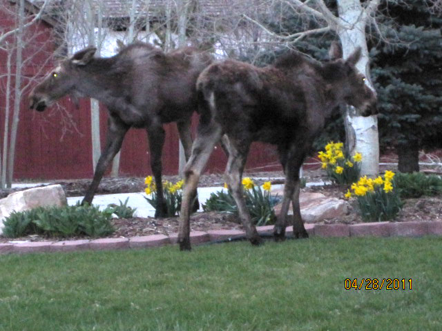
We would like to suggest our first choice for the new city name: “Moose Valley, Summit County, Utah” as an appropriate and more descriptive name for our new city. There is a large population of moose in this valley area with numerous sightings from Summit Park, Jeremy Ranch, Pinebrook, Sun Peak, Silver Springs, Ranch Place, White Pine Canyon, etc. throughout the season of each year. The name “Moose Valley” is conducive to the nature of this area, conjuring up visions of evergreens, snow, open space, nature, and outdoor activities. “Moose Valley” on the north correlates well with Deer Valley to the south of Park City.
Another popular name could be Kimball, Summit County, Utah. Kimball Junction lies in the heart of this valley area. The story of Melissa Burton Coray Kimball is compelling. A mountain was named after Melissa in California after she walked with her husband Private William Coray from Iowa to San Diego to Sacramento, to Utah as a U.S. Army wife until William died in c.1848. Melissa then married William H. Kimball owner of the Pony Express station and local stage line in Summit County at the now named Bitner sheep ranch. Melissa Kimball ran the hotel, station, and post office for many years, though William Kimball was usually given the credit (he lived in SLC). Melissa and her children lived in Summit Park possibly until her death in 1903.
In the 1960’s when ParkWest Ski Area was first developed this area was known as ParkWest. But the name “North Park” seemed to catch more interest as a city name during early incorporation discussions.
Another name to consider is “Lincoln, Summit County, Utah.” The Lincoln Highway runs along Highway 189 and Interstate 80 traversing the heart of this Summit County basin valley and Kimball Junction. Also one of the oldest families in this area included Maude Lincoln Snyder. Maude lived in a small house on Highway 224 in the center of the aging cottonwood trees adjoining the new Snyder’s Mill subdivision. I believe Maude lived there until around 1987.
Proposed incorporation area map:
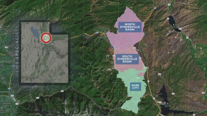
This graphic shows a portion of the 84098 zip code area named Moose Valley as North and South “Synderville” (a too common typing error) correctly spelled Snyderville. The Basin residents prefer the area to be called and named “Moose Valley”
The map shown on the TV news and on the Internet seems to show North Snyderville Basin as Silver Creek Estates, Red Hawk, Black Hawk Station, Glen Wild, Highland Estates, Silver Summit, Trailside, maybe Stagecoach Estates (has been renamed), etc. but does not go west enough to also include the NW corner of zip code 84098. The Park City School District includes all of 84098 inclusive of all of the areas named plus areas left off the map such as Pinebrook (including Toll Canyon), Jeremy Ranch, Hidden Cove, Timberline, Gorgoza, Sunrise Hills, etc.
The South Snyderville Basin portion of the map seems to include Kimball Junction, Ranch Place, Silver Springs Community, Sun Peak, ParkWest Village, Old Ranch Road, Bear Hollow, White Pine Canyon, etc. up to and contiguous with the Park City boundary at Osguthorpe’s farm, St. Mary’s Catholic Church, and the Jewish Temple Har Shalom.
We think it would be a mistake to leave those areas out of the incorporation and isolated between the Salt Lake County wilderness area boundary beginning at Parley’s Summit and the proposed incorporated area shown on the published map since they are all in the same school district and zip code 84098.
2006 Moose in NorthShore pond before cattails took over